Hyderabad Metro Rail has transformed urban mobility in the city, connecting major residential, commercial, and IT hubs with a modern, efficient, and eco-friendly transportation system. Whether you’re a daily commuter or a first-time traveler, understanding the metro timings and route map will help you plan your journey better.
Metro Train Timings
Hyderabad Metro Rail ensures seamless connectivity across the city with extended operational hours designed to accommodate both early risers and late-night commuters.
Operational Timings:
- Monday to Sunday: First Train departs at 6:00 AM, Last Train departs at 11:00 PM from all terminal stations
- Trains run at regular intervals throughout the day, with frequencies adjusted during peak and off-peak hours
- On weekdays, peak hour frequency is approximately 4-6 minutes, while off-peak hours see trains every 8-10 minutes
The consistent schedule across all seven days of the week makes Hyderabad Metro a reliable choice for daily commuters, weekend travelers, and tourists exploring the city.
Hyderabad Metro Route Map Overview
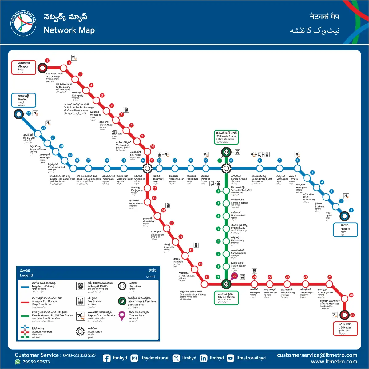
With three interconnected lines spanning over 69 kilometers and serving 57 stations, Hyderabad Metro offers fast, reliable, and convenient commutes across major corridors of the city. The color-coded system makes navigation simple and efficient.
Red Line – Miyapur to L B Nagar
The Red Line is the longest corridor, covering the east-west stretch of Hyderabad. It connects major areas including:
- Route: Miyapur to L B Nagar via MG Bus Station, Nampally & Ameerpet
- Key Stations: Miyapur, JNTU College, Kukatpally, Ameerpet, Prakash Nagar, Nampally, Malakpet, Dilsukhnagar, L B Nagar
- Coverage: Passes through important commercial and residential areas
This line is particularly useful for commuters traveling between the western suburbs and eastern parts of the city, covering prominent locations like the business district around Ameerpet and the bustling markets of Dilsukhnagar.
Green Line – JBS Parade Ground to MG Bus Station
The Green Line serves the northern corridor, connecting Secunderabad with the central business district.
- Route: JBS Parade Ground to MG Bus Station via Secunderabad
- Key Stations: JBS Parade Ground, Parade Ground, Secunderabad, Gandhi Hospital, Musheerabad, MG Bus Station
- Coverage: Links railway stations, hospitals, and central market areas
This corridor is essential for passengers arriving at Secunderabad Railway Station and those accessing healthcare facilities like Gandhi Hospital.
Blue Line – Nagole to Raidurg
The Blue Line connects the IT corridor with eastern Hyderabad, serving thousands of tech professionals daily.
- Route: Nagole to Raidurg via Secunderabad & Ameerpet
- Key Stations: Nagole, Uppal, Stadium, Paradise, Secunderabad, Ameerpet, Panjagutta, Jubilee Hills Checkpost, Madhapur, Hitec City, Raidurg
- Coverage: Major IT hubs including Hitec City, Madhapur, and Gachibowli, along with commercial centers
The Blue Line is the lifeline for IT employees working in the HITEC City and Gachibowli areas, offering a traffic-free commute option.
Strategic Interchange Stations
Hyderabad Metro’s three interchange stations enable seamless transfers between different lines, making it possible to reach virtually any part of the connected network efficiently.
MG Bus Station – Connects Red Line and Green Line This major interchange point serves as a hub for commuters traveling between the northern and eastern/western corridors. Located in the heart of the city, it also provides easy access to local bus services.
JBS Parade Ground – Connects Green Line and Blue Line Strategically positioned near the historic Parade Ground area, this interchange facilitates smooth transitions between the northern corridor and the IT route.
Ameerpet Station – Connects Red Line and Blue Line Perhaps the busiest interchange on the network, Ameerpet Station serves as the meeting point for the Red and Blue Lines. This station is crucial for commuters traveling from western residential areas to the IT corridor or vice versa.
Planning Your Journey
To make the most of Hyderabad Metro services:
- Download the Official App: Use the HMRL Connect app for real-time train tracking, trip planning, and digital ticketing
- Purchase Metro Cards: Save time with rechargeable metro cards available at all stations
- Peak Hours: Expect higher crowds during morning hours (8:00 AM – 10:00 AM) and evening hours (5:30 PM – 8:00 PM)
- First & Last Train: Always check the first and last train timings if you’re traveling early morning or late evening
Benefits of Hyderabad Metro
The metro system offers numerous advantages for daily commuters:
- Air-conditioned comfort throughout the journey
- Reduced travel time compared to road transport during peak hours
- Environmentally friendly alternative to private vehicles
- Affordable fare structure with distance-based pricing
- Safe and secure travel with CCTV surveillance and security personnel
- Accessibility features for senior citizens and differently-abled passengers
Future Expansions
Hyderabad Metro Rail is continuously expanding its network to cover more areas of the city. Proposed extensions and new corridors are in various stages of planning and implementation, promising even better connectivity in the coming years.