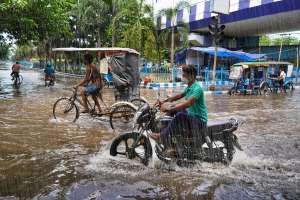
The southwest monsoon has officially arrived in Lakshadweep and Kerala, spreading into parts of Karnataka and Tamil Nadu. In the next 48 hours, weather experts expect the monsoon to advance further. It will likely move into the central Arabian Sea, cover Goa, and reach more areas of Maharashtra, Andhra Pradesh, and the rest of Tamil Nadu. Some regions near the Bay of Bengal will also begin to experience monsoon activity, according to the India Meteorological Department (IMD).
A weather system known as a trough is forming between Ratnagiri and Dapoli along the south Konkan coast. At the same time, the IMD predicts a low-pressure area will form over the west-central and north Bay of Bengal by May 27. This could bring scattered rainfall to parts of Telangana over the next couple of days.
On Sunday, light rain and thunderstorms are expected in isolated areas of Adilabad, Nirmal, Nizamabad, Sangareddy, Medak, and Kamareddy in Telangana.

In Andhra Pradesh, the combination of the Arabian Sea trough and the possible low-pressure system near the Bay of Bengal could bring heavy rainfall to some areas. Coastal regions may also experience strong winds reaching speeds of 40–50 km/h over the next three days. The Andhra Pradesh Disaster Management Authority has urged people to stay alert for thunderstorms and lightning risks.
Officials from the IMD say that light to moderate rain and thundershowers are likely on Sunday in districts such as Alluri Seetharamaraju, Anakapalle, Kakinada, East Godavari, Kurnool, and Nandyal.
By Monday, more widespread showers are expected. Moderate rain is likely across several districts including Srikakulam, Eluru, NTR, Krishna, Palnadu, Guntur, Bapatla, Prakasam, Anantapur, Sri Sathyasai, Annamayya, Chittoor, and Tirupati. Residents in these areas should prepare for wet and windy conditions.