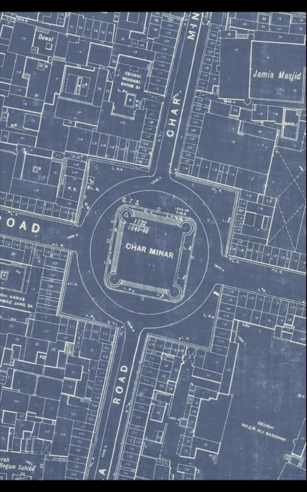
Hyderabad: Historic survey maps of the Charminar area have brought renewed focus on the original boundary walls and spatial layout of the iconic monument, highlighting the importance of scientific documentation in heritage conservation.
Experts speaking at the History Literature Festival in Hyderabad underlined how spatial technology, remote sensing, and aerial surveys are crucial in accurately mapping monuments like Charminar and understanding their original extents. The discussion drew attention to old survey maps that clearly show boundary walls surrounding Charminar, many of which have either disappeared or been absorbed into later urban development.
Invisible Archaeology and Lost Boundaries
The session, titled “Invisible Archaeology: Discovering the Past from Space”, featured heritage conservation practitioner Kuili Suganya and archaeologist M.B. Rajani of the National Institute of Advanced Studies. They explained that archaeological sites in India often overlap with agricultural lands, residential settlements, and commercial areas, making it difficult to visually identify original boundaries.

According to the experts, over centuries, what may have started as pathways around monuments gradually evolved into busy roads. In the case of Charminar, old maps indicate that the monument once stood at the centre of a more clearly defined spatial zone, unlike its present setting amid dense markets and traffic.
Charminar’s Changing Urban Context
Citing historical surveys, the speakers noted that while Charminar today is surrounded by bustling commercial activity, it once played a central role in the planning of the imperial city of Hyderabad in the 1700s. Remnants of boundary walls, doorways, and markers still exist in pockets around the monument but have largely been repurposed or integrated into civilian constructions.
The experts stressed that such changes highlight how urban growth has gradually erased visible markers of heritage boundaries, making old maps and surveys vital records for conservation planning.
Need for Scientific Mapping to Protect Heritage
Emphasising the need for modern tools, the speakers said that aerial documentation and satellite-based surveys are increasingly necessary to protect what remains of historic monuments. Accurate mapping can help authorities identify original extents, prevent further encroachment, and plan sensitive redevelopment around heritage zones.
Drawing parallels with other heritage sites, including the Mahabodhi Temple complex in Bodh Gaya, the experts cautioned that even globally recognised monuments are vulnerable to damage if surrounding development is not carefully regulated.
Preservation Through Documentation
The discussion concluded with a call for stronger integration of historical survey records, modern technology, and urban planning to ensure long-term preservation of Charminar and similar monuments. Experts noted that documenting and understanding invisible boundaries is a critical step in safeguarding Hyderabad’s layered history for future generations.